
Oklahoma Map
|
 |
 |
Where Is Oklahoma?
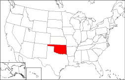
The location of Oklahoma is shown in red on this outline map of the 50 states. The State of Oklahoma is bounded by Kansas on the north, by Texas on the south, by Arkansas on the east, and by New Mexico on the west. Oklahoma is bordered by Missouri to the northeast, and by Colorado to the northwest.
Oklahoma Maps
Oklahoma is the 19th largest state in the United States; its land area is 68,667 square miles (177,848 square kilometers). The state is divided into seventy-seven counties. This Oklahoma map site features road maps, topographical maps, and relief maps of Oklahoma. The detailed, scrollable road map displays Oklahoma counties, cities, and towns as well as Interstate, U.S., and Oklahoma state highways. The pannable, scalable Oklahoma street map can be zoomed in to show local streets and detailed imagery.
Oklahoma Highway Map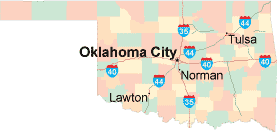 Click on the highway map thumbnail
to view a scalable Oklahoma road map. |
OK Topo Map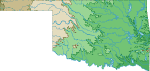 Click map to enlarge.
|
OK Relief Map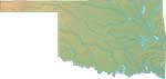 Click map to enlarge.
|
The detailed Oklahoma map and the regional Oklahoma map display cities, roads, rivers, and lakes as well as terrain features. The detailed map shows only the State of Oklahoma, while the regional map shows Oklahoma and the surrounding region.
Oklahoma Infrastructure > Oklahoma Airports
In 2005, the population of Oklahoma was estimated at 3,543,442, which is about 51.7 people per square mile. In 2010, Oklahoma's population rose to 3,751,351 people. More recently, in the 2020 census, the Oklahoma population was 3,959,353. The state's Interstate Highways include I-35, I-40, and I-44.
Oklahoma Topography
Oklahoma is derived from the Choctaw words "okla" and "humma", meaning "people" and "red", respectively. In Oklahoma's western panhandle, the Black Mesa abuts the foothills of the Rockies, but most of Oklahoma is part of the Great Plains. Numerous lakes are found in eastern Oklahoma, and the Ouachita Mountains rise in the southeast. The state's primary rivers are the Arkansas and the Canadian; the Red River forms Oklahoma's southern border with Texas. Historic landmarks include the Will Rogers Memorial, the Cherokee Cultural Center, and the National Cowboy Hall of Fame.
For Oklahoma travel and tourism information, visit the official Oklahoma tourism site and Oklahoma Atlas.
Other Maps of Oklahoma
This Oklahoma reference map shows major cities, roads, railroads, and physical features in Oklahoma.Several map publishing companies offer printed maps of Oklahoma. For example, Omni Resources offers several maps of Oklahoma that feature points of interest, airports, and parks, as well as selected local attractions and insets of major Oklahoma cities.
All rights reserved.
Certain maps hereon are © Map Resources or Digital Wisdom.
To facilitate browsing, certain external links will open in new windows.
Oklahoma-Map.org Editor, State Maps, PO Box 828, Barnegat, NJ 08005.